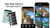
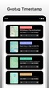
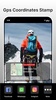

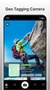
Gps Map Coordinates is a powerful Android app created to enhance your navigation and geotagging experiences. By integrating precise GPS technology, it enables you to tag your photos with accurate location data, including date, time, latitude, and longitude information. This functionality is designed to help you document your memories with unmatched clarity, ensuring you can easily revisit your captured moments without any hassle.
Comprehensive Geo-Tagging Features
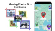
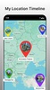
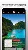
With Gps Map Coordinates, your photos will feature detailed geographic markers that enrich your storytelling. By using the integrated map and grid coordinate system, you can explore areas and pinpoint exact locations, whether you're traveling through bustling cities or navigating remote landscapes. The app provides an intuitive interface, allowing you to view and interact with map details while organizing your geotagged images effectively.
Enhanced Convenience and Customization
The app's streamlined tools simplify the process of capturing, storing, and sharing photos with location data. It offers extensive customization options, enabling personalized settings to match your preferences. This allows for a tailored photo-taking experience that suits your unique needs, making your adventures more meaningful.
Designed for Exploration and Sharing
Gps Map Coordinates is ideal for adventurers seeking to document and share their journeys. With its GPS coordinate finder and latitude-longitude tools, you can locate hidden sites or mark locations precisely. Sharing geotagged photos is seamless, ensuring your experiences can be shared with friends or preserved for future exploration.
Requirements (Latest version)
- Android 7.0 or higher required
Comments
There are no opinions about Gps Map Coordinates yet. Be the first! Comment